
- Hadrian’s Wall is a 74 mile (119km) Roman defensive stone wall with Forts at intervals, built by the Roman Emperor Hadrian between 122-128 CE. It is a Unesco World Heritage Site.
- The Wall runs east-west from the Irish Sea at Bowness-on-Solway to the North Sea at Wallsend, Newcastle.
The Name
- The Wall’s construction was ordered by the Roman Emperor Hadrian, and so we know it today as ‘Hadrian’s Wall’.
- In Latin, it was called the ‘Vallum Aelium’ or ‘The Wall of Aelius’, which was the family name of the Emperor Hadrian.
The Location
- Hadrian’s Wall stretches east-west across Northern England from the Irish Sea to the North Sea. (The narrowest part)
- It runs for 80 Roman miles, (73.5 miles or 117 km) from Bowness-on-Solway, near Carlisle to Wallsend.
- The Wall runs to the north of the River Eden and to the north of the River Tyne. In the east, the Wall runs along the top of a Ridge of rock known as the ‘Whin Sill’.
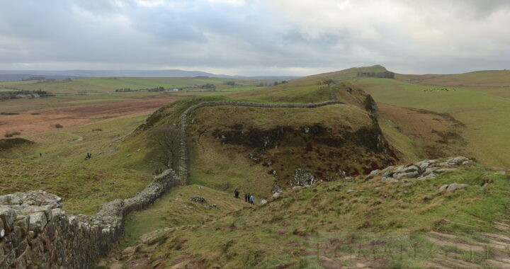
Sycamore Gap
- The Sycamore Gap is a dip in the landscape where a sycamore tree once stood next to Hadrian’s Wall near Once Brewed, Hexham, in the Northumberland National Park. It was one of the most photographed trees in England.
- The Gap is located 2 miles (3km) west of Houseteads Roman Fort near Crag Lough and was featured in the movie ‘Robin Hood: Prince of Thieves’ (1991) starring Kevin Costner as Robin Hood.
Route of Hadrian's Wall
Date and Reason for its Construction
- It was constructed between 122-128 CE. The order for its construction was given by the Emperor Hadrian.
- The Wall was built to stop invading Caledonian Tribes from heading south.
The Legions who built the Wall
- Eastern section: (along the river Tyne)
- Legio VI Victrix (122-128 CE)
- Built the entire Eastern section of the Wall. They also built the Fort at South Shields and the Bridge over the Tyne at Newcastle (Pons Aelius).
- Legio VI Victrix (122-128 CE)
- Western section: (along the rivers Eden and Irthing)
- Legio II Augusta
- Legio XX Valeria Victrix
- Together they jointly built the Western section.
- The Granaries at Benwell Hill and Halton Chesters
- The Classis Britannica, the Roman Navy in Britannia supplied the Grain and built the Granaries.
How the Wall functioned
- The Advance Fortlets
- There is a row of Roman Fortlets set 5-10 miles (8-16km) north of the Wall, which acted as advance signalling Posts.
- The Ditch
- A deep ‘V’ Ditch trench was dug in front of the Curtain Wall, to protect it from frontal attack.
- The Wall
- Hadrian’s Wall was a Stone wall with Towers at intervals, runnning for 74 miles, from Bowness-on-Solway to Wallsend:
- The Wall was 8-10 feet (2.5-3m) wide and 16-20 feet (5-6m) high. The stone came from local quarries.
- Soldiers walking along the rampart of the Wall were protected from arrows and slingshots by crenellations.
- The Milecastles
- 80 Towers were built between the Forts at one roman mile intervals. They contained a Gateway through the Wall with a northern Causeway across the Wall Ditch. They had a Garrison of 20-30 Auxiliary soldiers accommodated in two Buildings.
- They are numbered 0 and 1 from the east to 80 in the west, as in MC3 or MC20. (MC means Milecastle).
- The Turrets
- 158 Turrets were built at a distance of one third of a Roman mile, either side of each Milecastle. They are numbered 3a to the east of MC3, and 3b to the west of MC3.
- Where the Milecastles finish west of Bowness-on-Solway and the Mileforts begin, the Turrets are again placed one third of a mile, and two thirds of a mile to the west of each Milefort.
- They are numbered a and b, as in 7a and 7b, anticlockwise from MF7.
- The Roman Forts
- 16 of these are positioned either behind or on the Wall between 5.5 and 9.5 Roman miles apart.
- Each held a Garrison of between 500 to 1,000 men.
- The Cumbrian Coast Towers
- The Wall ends at Bowness-on-Solway, but Towers continued around the Cumbrian Coast.
- The Towers are referred to as MileForts (instead of Milecastles) and are numbered 1 – 26, as in MF7. (MF means MileFort).
- The MileForts continued past Bowness-on-Solway, along the Cumbrian Coast, at least as far as Maryport and possibly further, to protect the Wall’s western flank from seaborne raids.
- The Military Way
- This is a very narrow Road that runs east-west between the Wall and the Vallum, and was used for troop movements and communication between the Forts.
- It was too narrow to be used by vehicles, only cavalry and soldiers.
- The Vallum
- The Vallum was located behind the Wall and consisted of a very wide Ditch running parallel to the Wall.
- It appears to have defended the Wall and the Forts from attack from behind. Parts of it can still be seen today.
- The Vallum behind Hadrian’s Wall was a 20 foot (6m) wide ditch with embankments on both sides, similar to the Fossatum Africae in Algeria which also consisted of a ditch 10-20 feet (3-6m) in width, with embankments on both sides.
- Hadrian’s Timber Wall
- During the Wall’s construction in stone, a temporary screen of wood was erected in front to protect the Wall. This was revealed when lines of Post holes were excavated, a few yards in front of the Wall.
The Soldiers and their Commanders
- The Commanders
- York:
- Overall control was under the ‘Duke of the Wall’ based at his HQ in the Roman Legionary Fortress of the Legio VI Victrix.
- Stanwix:
- The Forward HQ was at the Fort at Stanwix on the Wall, and commanded by the Prefect of a Roman Cavalry Regiment of 1,000 Horse.
- Stanwix was connected to York by a Roman Road, described in Iter II.
- York:
- The Soldiers
- There were approximately 10,000 Roman Auxiliaries.
- The 16 Forts along the Wall, usually had 500 men to a Fort, and so were manned by around 8,000 Auxiliaries.
- At each end of the Wall was a 1,000 unit Cavalry Fort, bringing the total number of soldiers to 10,000.
- Unlike the Antonine Wall, Hadrian’s Wall was not manned by Legionaries from the three Roman Fortresses, but by Roman Auxiliaries.
- The Auxiliaries collected their pay from York, as they were attached to the Legio VI VIctrix.
The Tactics of Defending the Wall
- Although the HQ for the Wall was at York, and the forward HQ was the Roman Fort at Stanwix, to the north of Carlisle.
- Small signalling Forts (Milecastles) were stationed one mile apart, and these sent regular messages back to the Main Forts along the Wall, who then relayed them back to the HQ at Stanwix. Stanwix would then liaise directly with York.
- If the enemy appeared, warning signals would be sent to the nearest Fort. The troops would then move up to defend that section of the Wall. More signals could be sent between the Forts to request backup.
- The nearby Forts would then send men to march along the Military Way, to the section under attack.
- If a major attack was under way, the Legions from York and Chester would then be mobilised to move north and stop the incursion.
The Wall was overrun four times
- We know of four separate occasions when the Wall was overrun by invading armies:
- Three incursions happened shortly after the Antonine Wall was abandoned in 164 CE. The first was in 180 CE, another in 190 CE and again in 197 CE.
- These incursions led to Septimius Severus' Caledonian Campaign between 208-211 CE, and the re-occupation of the Antonine Wall.
- The fourth incursion occurred during The Great Conspiracy in 367-8 CE. The Auxiliary soldiers colluded with the invaders and let them pass through the Wall.
- After this invasion, Count Theodosius set up the fifth Province of Valentia in 369 CE to act as a buffer zone. It was the area to the north of the Wall, with its capital at Carlisle, possibly extending as far as the Antonine Wall.
- After this there were no further incursions until the Romans withdrew from the Wall completely in c. 408-410 CE.
The Stanegate
- The Stanegate was the original defensive line built to the south of the Rivers Eden and Tyne.
- It consisted of a 44 mile (78km) long Roman Road between Carlisle and Corbridge, with 10 Forts placed at intervals but no connecting wall.
- Subsequently in 128 CE, this line was moved to the north of these rivers, and became Hadrian’s Wall.
- However, the Stanegate continued to remain active as the only cart road running east-west, since the Military Way behind Hadrian’s Wall was not built for wheeled traffic.
- After Hadrian’s Wall was built, the Stanegate Forts continued to be occupied, as documented by the Vindolanda Tablets. The forts acted as a defense in reserve and the Stanegate road supplied the forts along Hadrian’s Wall.
The Antonine Wall
- In 139 CE, Antoninus Pius ordered the construction of the Antonine Wall and moved the Frontier almost 100 miles (160km) north, only 11 years after Hadrian’s Wall had been completed in 128 CE.
- The Antonine Wall operated between 139-164 CE, from Edinburgh to Glasgow.
- However, the Antonine Wall was overrun, and Marcus Aurelius (161-180 CE) ordered it to be abandoned. By 164 CE the Frontier had returned to Hadrian’s Wall.
- After at least three incursions, the Antonine Wall was briefly reoccupied during Septimius Severus' Caledonian Campaign between 208-211 CE.
The Wall is Abandoned (406-410 CE)
- Hadrian’s Wall was abandoned sometime between 406-410 CE.
- The British Legions were taken to Gaul to fight the Germanic invasions and never returned.
- In 409-410 CE, the Emperor Honorius sent the Rescript of Honorius, which was a letter to the Britons telling them they had to look after their own defence.
Other Fortified Roman Frontiers
- The Romans frequently used Lines of Fortifications along the Roman Frontiers, but usually they were made of earth and turf.
- These Walls were called ‘Limes’, meaning a ‘Frontier’, such as the Limes Germanicus, which ran along the Rhine and the Danube.
- No other Wall is as well preserved as Hadrian’s Wall.
- The Anastasian Wall (507-512 CE) designed to protect Istanbul, was built in a very similar way with Forts, Gates, a Ditch and a Military Way.
Roman Roads
- Military Way
- running behind Hadrian’s Wall.
- Dere Street
- From York to the Antonine Wall
- Stanegate
- Carlisle to Corbridge.
Nearby Sites
- South Shields Roman Fort (Arbeia)
- Wallsend Roman Fort (Segedunum)
- Newcastle upon Tyne (Pons Aelius)
- Corbridge (Corstopitum)
- Maryport (Alauna Carvetiorum)
- Ravenglass (Glannoventa)
Films and DvD’s set near Hadrian’s Wall
- Robin Hood: Prince of Thieves (1991)
- with Kevin Costner, Morgan Freeman, Alan Rickman and Mary Elizabeth Mastrantonio.
Photo and map: Hadrian’s Wall Path near Crag Lough, Northumberland