
- All roads lead to Rome. During the Roman Empire travellers could journey at any time of year by a system of all weather roads from Rome to any part of the Empire.
- Within each Roman town, city or fort was a grid system of roads. There were Maps, a Highway Code, Hotels, Way Stations and a Postal system. Many of the roads are still visible today.
A-Z of Roman Roads
The Three Types of Roman Roads
- Public roads
- Viae Publicae, consulares, praetoriae or militares. Constructed by the government using public funds.
- Private Roads
- Viae Privatae, Rusticae, glareae or agrariae. Constructed by private individuals or villa owners using private funds.
- Minor roads
- Viae Vicinales which passed through a small village or vicus and were constructed by the municipality.
Bars
- Thermopolium, Taberna and Popina were roadside cafes or bars.
Bridges, Causeways and Tunnels
- Rivers were crossed at all times of year by Roman Bridges built using the Roman Arch.
- Bogs and fens were crossed by building Causeways made by sinking wooden piles then placing layers of stones above the level of the marsh or by using log roads using small tree trunks.
- Some Mountains or Passes were crossed by Roman Tunnels.
Coaching Inns
- Mansio:
- The Mansio was part of an organisation of roadside Inns located along major Roman Roads at intervals of 15-20 miles (25-30km) for changing horses and overnight stays.
- They were Villa complexes managed by a Mansionarius, where Senior Roman Officials and important travelers, could stay overnight and eat, as well as change their horses. Transport could also be hired out.
- Cauponae:
- Less reputable taverns near to the Mansios for overnight stays.
- Tabernae:
- A more up market inn for more important travellers.
- Mutationes:
- These were ‘changing stations’ for servicing vehicles and changing horses at every 15-20 miles (25-30 km).
Construction Method
- Civil Engineer
- He chose the route and the surveyors then planned the roadbed.
- Surveying
- The roadbed was planned by Surveyors called the Gromatici or Agrimensores. They used a Groma and Rods. The surveyor looked through the Groma to visualise a straight line whilst his assistant laid down the rods. The Groma could also mark right angles.
- Earth Bed
- This was excavated, levelled and compacted by ramming.
- Statumen
- The foundation consisted of a solid base of small stones which were laid on the prepared flat surface and then pounded to provide stability and drainage.
- Audits
- Above this was placed a layer of rubble and stones mixed with lime.
- Nucleus
- Next was a bed of cement consisting of pottery shards and lime.
- Layer of Sand
- A layer of sand, sometimes mixed with clay, was usually 1 foot (0.3m) deep, but could be up to 3 feet (1m) in thickness.
- Agger Viae, the Surface
- Via terrena:
- An earth trackway with a levelled earth surface.
- Via glareata:
- Usually an earth road with a gravelled surface.
- Via munita:
- A layer of stone slabs or hexagonal volcanic blocks, laid out in a convex curve to help drainage.
- Via terrena:
- Umbones or Edgestones
- The kerbstones in towns.
- Crepido
- A raised pavement in towns.
- Width
- Most Roman roads were between 12 to 14 Roman feet (3.6-4.2m) wide allowing two Roman carts of 4 feet (1.2m) width to pass one another. The Via Appia was 36 feet (10.9m) wide.
Dual Carriageways
- As Roman Roads approached within a few miles of Rome, they became Dual Carriageways.
Highway Code
- The Roman Highway Code
- This was called the Lex Iulia Municipalis.
- Traffic in Ancient Rome was only allowed to move at night within the City Walls and up to one Roman mile outside of them. Traffic was forbidden by day.
Maintenance
- Under the Roman Republic (509-27 BCE), the Censors were given responsibility for the construction, maintenance and financing of the roads.
- Augustus (27BCE-14 CE) took over their responsibilities and from then on the Emperors themselves became responsible for the construction, maintenance and financing of the roads.
Maps
- Antonine Itinerary
- A fourth century CE list of Routes around the Roman Empire.
- Peutinger Table
- The Peutinger Table is a Michelin style road map of the Roman Empire.
Milestones
- The Milliaria
- The Roman milestone was called a Milliaria or Lapides.
- It was usually a cylindrical pillar made of stone or marble and placed at intervals of one Roman Mile.
- The Roman mile
- The Roman Mile was 1,000 paces, each pace being 5 Roman feet, making it 4,590 ft long (1,430m).
- Inscriptions
- The milestone bore an inscription which gave the name and titles of the reigning Consul or Emperor and sometimes, but not always, the mileage from a named town. Some carried the name of the official contracted to make repairs. In Turkey and other Provinces, the Roman milestones were inscribed in both Latin and Greek.
- About 100 Roman milestones have survived in Britain.
Postal Service
- The Cursus Publicus, also known as the Cursus Vehiculorum, was the Postal Service of the Roman Empire.
- It transported the Mail, Officials and Tax Revenues along the Roman Roads between Rome and the Provinces.
Point Zero
-
- All distances were measured from the Umbilicus Urbis Romae. a Point Zero or Kilometre Zero in Rome.
- Umbilicus Urbis Romae
- The ‘Navel of the City of Rome’ was Ancient Rome’s Kilometre Zero, located next to the Milliarium Aureum.
- It was a marble covered brick structure from which all distances to the cities in the Roman Empire were measured. Only the brick centre survives today.
- Milliarium Aureum
- All distances from Rome were measured from the Umbilicus then recorded on the Milliarium Aureum
- This was a stone column shrouded in Bronze on which all distances from Rome were written upon. It was located in the Forum Romanum, probably next to the Temple of Saturn, where it became a meeting point and a venue for Public Speeches. It no longer exists today
- The Master Itinerary
- The Master Itinerary of all the Roman roads in the Empire was placed on a Stone Engraving near the Pantheon in 19 BCE.
Post Stations
- Statio
- The Statio was a Post Station or Office at set intervals along all the major roads of the Roman Empire.
- It was manned by the Milites Stationarii, who were Roman Legionaries, temporarily seconded to police the roads of Italia and the Roman Provinces.
- Stationarius
- The Stationarius would be assigned to a specific post on a specific road, eg, ‘Stationarius Via Appia’.
Tolls
- There were Tolls on Bridges and at City Gates and these paid for the Road Maintenance.
Town Roads
- Roman Town Planning ensured that all Roman towns, cities or forts had a grid system of streets based on two intersecting roads:
- Cardo Maximus
- or Cardo, was the main north-south road.
- Decumanus Maximus
- was the main east-west road that intersected the Cardo.
- Roman Forum
- Every Roman town or city had a Forum placed at the intersection of these two main roads.
- Pavements
- Roads in towns had a raised pavement on either side, as seen in Pompeii.
- Cardo Maximus
Roman Vehicles
- Vehicles such as wagons and carts were hauled by Horses, Mules and Oxen.
Roman Roads of Italy
- Ten Roman Roads radiated from the City of Rome. They were all Ancient trackways that started being paved from 312 BCE onwards.
Roads of the Roman Empire
- The Roads of the Roman Empire connected the Roman Provinces with each other and with Rome.
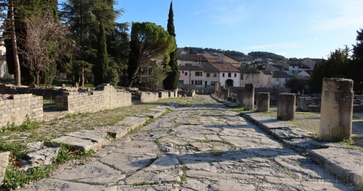
Photo: Road in Vaison-La-Romaine, southern France