
- Panoramic Views of the heart of Paris can be obtained from the elevated sections of the Paris Metro on Line 6, Line 2 and briefly on Line 5 and Line 1.
- The river Seine is bridged in three places with Line 6 crossing the Seine twice over the Pont de Bir Hakeim and the Pont de Bercy, and Line 5 crossing it once over the Viaduc d’Austerlitz.
Line 6: ♥♥♥♥♥
- Elevated between Passy and Pasteur, then Saint Jacques and Bercy
- Termini: Charles de Gaulle Etoile-Nation
- This is the best Metro line for sightseeing as almost half of the line is elevated and it crosses the river Seine twice over two separate bridges.
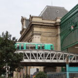
- The six stops between Passy and Pasteur are elevated, as are the eight stops between Saint Jacques and Bercy.
-
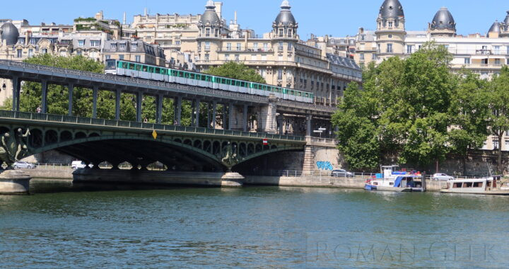
- From Charles de Gaulle Etoile, the train emerges at Passy and bridges the Seine at the Pont de Bir Hakeim, with a panoramic view of the river Seine and the Eiffel Tower. The line then runs above the streets until Pasteur where it goes underground.
- It re-emerges at St. Jacques, crossing the Seine again on a viaduct above the Pont de Bercy, with more panoramic views of the Seine, before re-entering the tunnel at Bercy.
-
- Line 6 Metro Stations
- Charles de Gaulle-Etoile (Terminus)
- Kleber
- Boissiere
- Trocadero
- Passy
- RUNS ABOVE STREET LEVEL
- BRIDGE OF BIR-HAKEIM: PANORAMIC VIEWS OVER THE SEINE AND THE EIFFEL TOWER.
- Bir-Hakeim
- Dupleix
- La Motte-Picquet-Grenelle
- Cambronne
- Sevres-Lecourbe
- Pasteur
- RE-ENTERS THE TUNNEL
- Montparnasse-Bienvenue
- Edgar Quinet
- Raspail
- Denfert-Rochereau
- RUNS ABOVE STREET LEVEL
- Saint-Jacques
- Glaciere
- Corvisart
- Place d’Italie
- Nationale
- Chevaleret
- Quai de la Gare
- BRIDGE OF BERCY: VIEWS OVER THE SEINE
- Bercy
- RE-ENTERS THE TUNNEL
- Dugommier
- Daumesnil
- Bel-Air
- Picpus
- Nation (Terminus)
Line 2: ♥♥♥
- Elevated between Barbes Rochechouart and Jaures
- Directions: Nation-Porte Dauphine.
- This line is only partially elevated above street level for four stops.
- The elevated section runs between the stations of Barbes Rochechouart and Jaures.
Line 5: ♥♥
- Elevated between Gare d’Austerlitz and Quai de la Rappee
- Directions: Place D’Italie-Mairie des Lilas.
- Line 5 only emerges once above street level.
- Line 5 only emerges once above street level.
- Gare d’Austerlitz
- It climbs up a steep track and enters the Gare d’Austerlitz Metro Station which is located in the roof above the Gare d’Austerlitz Mainline Station.
- Viaduc d’Austerlitz
- It then emerges onto the Viaduc d’Austerlitz which crosses the River Seine and descends steeply on the opposite bank to enter the Quai de la Rappee Station. Unlike Bastille, the station has no views over the canal. After crossing above the twin locks of the Canal Saint Martin, the line re-enters the tunnel.
- Directions: Place D’Italie-Mairie des Lilas.
Line 1: ♥
- The View from the southern Platform at Bastille Station
- Line 5 and Line 8 also have stations at Bastille.
- However, it is Line 1 that has a unique station reached by a very tight curve followed by a counter curve. The station is partly underground and partly overground on a bridge over the canal entrance to the Bastille tunnel. The western end of the platforms have the sharpest curve on the Paris Metro.
- The open air platform in the direction of Chateau de Vincennes has glass windows from the ground to the roof revealing a scenic view of the Saint Martin Canal and the Bassin de l’Arsenal, looking towards the Quai de la Rappee Metro station at the far end.
Paris Metro Map
Photo and map: Pont de Bir-Hakeim, Paris