Durrington Walls is a Bronze Age Henge Monument which had a population of c. 4,000 and was active around 2,300 BCE, the period of construction of Stonehenge.

Durrington Walls

  • Durrington Walls was a Bronze Age settlement of around 1,000 houses, 2 miles north east of Stonehenge in Wiltshire.
  • The community had a population of around 4,000, and was active from around 2,300 BCE, the period of construction of Stonehenge.

Description

  • Henge Monument
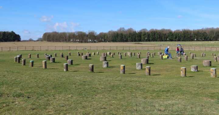
    • It was a circular area, 0.3 mile (500m) in diameter, surrounded by a Henge monument consisting of a circular Ditch and earth Embankment.
  • Astronomical Alignment
    • At the centre was a large Timber circle pointing towards sunrise at the Winter Solstice.
  • Circles
    • Within the main circle, there were four more concentric circles,
  • An Avenue
    • An avenue led to the River Avon oriented towards sunset at the Summer Solstice.

Nearby Monuments


Durrington Walls Henge Monument, Wiltshire

Adriatic

  • The Adriatic is a Sea that lies between Italy and the Balkan coasts of Croatia, Albania and Greece.
  • It was known to the Romans as the Mare Superum.

Description

  • The northern sea is shallow, starting at a depth of around 65-130 ft (20-40 m)
  • Further south the depth increases to over 3,930 ft (1,200 m) between Dubrovnik and Bari.

Roman Navy

  • The Sea Lanes of the Adriatic were patrolled by the Roman Praetorian Fleet, the Classis Ravennas, based at Ravenna.

Ports

  • Greece
    • Dyrrhachium
    • Apollonia


The Adriatic Sea

Socotra

  • Socotra is located in the Indian Ocean, 150 miles (240 km) east of the Horn of Africa, and 240 miles (380 km) south of the Arabian Peninsular.
  • Socotra is the largest Island of the Socotra archipelago, which consists of four islands.

Description

  • It was known as the island of Dioscorides to the Greeks.
  • The island measures 82 miles (132 km) in length, by 31 miles (50 km) in width.
  • Its highest peak is 4,931 ft (1,503 m).
  • It is part of the Yemen.
  • Because of the unique appearance of its endemic plants and trees, visitors to Socotra feel they have landed on another planet.

Trade with the Ancient World

  • Socotra was named ‘Dioskouridou’ (Dioscurides), in the Periplus of the Erythraean Sea.
  • Almost 250 Inscriptions and drawings have been found in a large cave on the island.
  • The inscriptions were written between c. 100 BCE and c. 600 CE in several languages including Indian, Brahmi, Ethiopian, South Arabian, Greek, Palmyrene and Bactrian, revealing the origins of the merchant vessels.

Frankincense

  • Frankincense can only be harvested on either side of the Gulf of Aden. Socotra was one of the Ancient World’s major sources of Frankincense, although the wealth from this trade went to the south Arabian Kingdoms, such as the Sabaean Kingdom.
  • The Ancient Egyptians were using Frankincense for Funeral Preparations and Medicinal purposes as early as 2,500 BCE.

Incense Road

Socotra Gyre

  • The Socotra Gyre is a large rotating water mass south of Socotra, which forms as a result of the Monsoon winds, along with the Great Whirl.

Sand Banks

  • Off the eastern point of Socotra, sand banks can extend up to ten miles (16km) offshore, making navigation hazardous.

Flora and Fauna

  • Flora:
    • Due to its isolation and the intense heat, the types of Tree, plant and wildlife that have evolved are endemic (unique) to Socotra.
    • The Centre for Middle Eastern Plants found 825 different types of plant on Socotra, of which 307 do not exist elsewhere in the World. Some examples are:
      • Dragon’s blood tree, which has a red sap and was used as a dye.
      • Aloes, used for medicine and cosmetics.
      • The great succulent tree.
      • Cucumber tree
  • Fauna:
    • The Socotra Starling, Socotra Bunting, Socotra Sunbird and the Socotra Sparrow are endemic (unique) to Socotra.
    • 90% of the reptile species are endemic (unique) to Socotra.
    • The only mammals that live on the island are bats.

History of Christianity

  • Thomas the Apostle
  • Marco Polo
    • In ‘The Travels of Marco Polo’ where he describes his voyages between 1276 and 1291 CE, he describes the local population of Socotra as still being Christian.


Socotra

Woodhenge is a Henge Monument located 2 miles from Stonehenge built in 2,500-2,000 BCE. It consists of six concentric oval rings made from 168 timber postholes.

Woodhenge

  • Woodhenge is a henge monument located 2 miles northeast of Stonehenge in Wiltshire and dating from between 2,500-2,000 BCE.
  • Woodhenge consists of six concentric oval rings made from 168 timber postholes. Its purpose remains the subject of debate.

Similarities to Stonehenge

  1. The Diameters of the timber circles
    • At Woodhenge the diameters are similar to the diameters of the Stone circles at Stonehenge.
  2. The entrance
  3. The post holes
    • These are arranged in a similar way to the Bluestones at Stonehenge.

Bronze Age Town

  • The Bronze Age community of 4,000 people at Durrington Walls is located 230 feet (70 m) north of Woodhenge.

Nearby Monuments


Woodhenge, Wiltshire

Andautonia

  • Andautonia was a Roman settlement on the banks of the River Sava near modern Zagreb in the Province of Pannonia Superior.
  • It is now an Archeological Park located 8 miles (14km) southeast of Zagreb in Croatia.

Andautonia Archeological Park

Museums

  • Archeological Museum in Zagreb
    • Located at 19 Nikol Subic, Zrinski Square, Zagreb
    • In the Antiquity Section, the museum holds artefacts excavated from all over Croatia including statues, military items, artwork and a large collection of Roman coins.

Roman Roads

  • A Roman Road connected:
    • Poetuvia-Andautonia-Siscia


Andautonia Archeological Park, Croatia

Bishapur

  • Bishapur was an ancient city whose Ruins are located in modern Faliyan in the Province of Fars, Iran
  • In 266 CE, the captured Roman Legionaries from the Battle of Edessa built the nearby city of Bishapur where they and Valerian lived.

Roman Ruins

  • Palace of Shapur I
    • with Roman Mosaics.
  • Temple of Anahita.
  • The Dam of Band-e Kaisar.


Bishapur Ruins, Iran

Equator

  • The Equator is an imaginary line which divides the World exactly into two halves, the Northern Hemisphere and the Southern Hemisphere.
  • The Earth is further subdivided into Parallels of Latitude which, when used in combination with Longitude, help determine the position of a location on Earth.

Description

  • The Equator is the zero Parallel of Latitude.
  • Each parallel of Latitude then extends North or South from 0° to 90°.
  • The 90° North Parallel passes through the North Pole, and the 90° South Parallel, passes through the South Pole.
  • At the Equator, the length of Day and Night are always exactly equal: Day is 12 hours long and Night is 12 hours long, every day of the year.
  • On the Equinoxes, the Sun is directly overhead the Equator at Midday.

Ancient Geographers

Celestial Equator

  • The Celestial Equator is a Great Circle or disc that divides the Earth’s Sphere into exactly two Hemispheres.
  • It is on precisely the same plane as the Equator.


Equator

Copper

  • Copper is a soft metal that can be used as an alloy with other metals.
  • In the Ancient World, copper was easily extracted by smelting from Copper ore.

History

  • The word Copper is from the Latin ‘Cyprium’, meaning the ‘metal of Cyprus’, and abbreviated to ‘Cuprum’.
  • This was because the majority of Copper production during the Roman Era came from Cyprus. It was shipped in Ingots around the Empire.

Bronze

  • Alloying Copper with Tin produces Bronze, and this discovery brought in the Bronze Age.
  • Bronze continued to be manufactured during the whole Roman Era.

Brass

  • Alloying Copper with Zinc produces Brass, known to the Greeks, but produced in great quantities during the Roman Empire.
  • After 23 CE, Augustus changed the silver Sestertius into a Brass coin, which continued to be issued up until the end of the third century CE, requiring large quantities of copper.

Copper Mines in the Ancient World

1. Cyprus

  • The Troodos Mountains Copper Mines
  • These were the Ancient world’s most productive Copper Mines.
  • The Skouriotissa Mines, amongst other Mines in the area, have 2,000,000 tons of slag.
  • The area has been mined since the early Bronze Age c. 3,000 BCE.
  • Cyprus, also known as Alashiya, was famed in the Ancient World for its Copper.
  • The Amarna Letters speak of the Pharaoh‘s trade in Copper with Cyprus.
  • The Uluburun Shipwreck, dating from the 14th century BCE, found in 1982 off the southern coast of Turkey, contained 355 Ingots of Cyprus Copper, and the vessel is thought to have originated in Cyprus.
  • The Romans extracted 250,000 tons of Copper up until the fourth century CE.

2. Wales

  • Great Orme Copper Mine.
  • Great Orme is a giant Bronze Age Copper Mine where copper has been excavated since around 2,000 BCE and was at its most productive between 1700-1400 BCE.
  • The Mine was closed in c. 600 BCE but reopened by the Romans.
  • The Mine is inside the Great Orme Promontory beside the town of Llandudno in North Wales.
  • It has been estimated that around 1,800 tons of copper ore were extracted from this Mine.

3. Southern Jordan

  • Wadi Faynan
  • Located in Southern Jordan contains a huge copper mining site.
  • Petra is located 30 miles (48km) to the south of these Mines and would have controlled the Copper trade.
  • Wadi Faynan was extensively mined throughout history, but particularly during the Roman Empire.
  • The area was also mined during the 10th century BCE,  the same period as King Solomon, and may be the source of the vast amounts of Copper needed to build the Temple of Jerusalem.
  • The site covers 13 square miles, contains 200,000 tons of slag and has been mined for 6,500 years.
  • Khirbat en-Nahas was also heavily mined in the 10th century BCE.

4. Southern Israel

  • Timna Valley
  • Located 19 miles (30km) north of Eilat, has 2,000 tons of slag and has been mined for Copper for over 6,500 years.
  • The so-called King Solomon’s Pillars are rock formations which stand at the end of the Timna valley, so named by the American Archeologist Nelson Glueck in 1930.
  • Just below the base of the Pillars was found a temple to Hathor, the Egyptian Goddess of Mining, built in the 14th century BCE.

5. Egypt

  • Sinai Peninsular
  • It holds the Wadi Meghara Copper and Turquoise Mines and the Wadi Nas’b holds an estimated 100,000 tons of copper slag.
  • Serabit el Khadim held turquoise Mines and the Temple of Hathor, the Egyptian Goddess of Mining.
  • Copper was mined in Sinai since the Pharaoh Khufu, also known as Cheops.
  • 100,000 tons of Slag would have produced approximately 5,500 tons of Copper.

6. Oman

  • Copper Mines of Oman.
  • They began extraction in 3,000 BCE.
  • The Sumerian clay tablets refer to two countries where Copper came from, one called called Dilmun (Bahrain) and the other called Magan, thought to be Oman.
  • The Sumer Civilisation received all its Copper from this area.

7. Andalucia, Spain

  • Rio Tinto Mines.
  • In the Huelva region are located the Rio Tinto Copper, Silver and Lead Mines.
  • The Rio Tinto mining complex in Huelva, Andalucia, also lays claim to being King Solomon's Mines.
  • The mines were worked from 1,000 BCE until the end of the Roman era after which they were closed and not reopened until 1556 CE.
  • Two villages nearby are named Zalamea la Real and Zalamea La Vieja (Nerva today) in an area called Cerro Salomon.
  • The Phoenicians traded with Spain for its metal ores as well as for its wines and Olive Oil.

8. King Solomon's Mines

  • Tell el-Kheleifeh.
  • The Legendary wealth of the Biblical King Solomon became a source of great interest during the Victorian Period after H. Rider Haggard published the novel ‘King Solomon’s Mines’ in 1885 describing the source as a diamond mine in Africa.
  • Then, in three seasons of digs between 1938-1940, the American Archeologist Nelson Glueck excavated a site at Tell el-Kheleifeh on the Gulf of Aquaba and declared that that he had found Copper Mines that were the source of Solomon’s wealth, and linked them to Ezion Geber mentioned in the Book of Kings I, 10:22.
  • Consequently, although The Bible makes no mentions of any Mines, the theory has become widely accepted.


Tell el-Kheleifeh, Eilat, Israel

Chinese Junk

  • The Chinese Junk is a wooden ocean going vessel that has been in continuous use for over 2,200 years.
  • It was in use during the Roman Period, and was first written about during the Han Dynasty (206 BCE-220 CE).

Difference with Square rigged vessels

  • It differed from Roman ocean going vessels by having a central stern mounted steerable rudder and sails that could be rotated through 180 degrees.
  • This allowed a Junk to sail close hauled and tack through the wind, whereas square-rigged Roman vessels had to ‘wear about’ and turn through 270° to change direction.

History

  • Wan Chen describes Junks in circa 250 CE, carrying 250 tons of cargo and 700 people.
  • Kang Tai describes Junks with seven masts in 260 CE, sailing to Syria.
  • One Junk excavation site dates the iron nails to 221 BCE.
  • The first pottery model of a Junk appears to date from the first century CE.
  • The Geographer Ptolemy wrote that Roman Merchants traded in Silk from China, with the port of Kattigara.
  • Kattigara is thought to be the archeological site of Oc Eo in Vietnam.

Construction

  • Hull:
    • The River Junk
      • This had a flat bottom with no keel. Instead of a keel, a large rudder was used to prevent the vessel slipping sideways. Sometimes a daggerboard or leeboard was used.
    • The Ocean Junk
      • This had a curved hull with a wide beam at water level which narrowed as it reached the top deck.
    • Bulkheads
      • The Junk was built with separate compartments divided by bulkheads which were accessed by individual hatches.
      • It is thought these were watertight, making the Junk virtually unsinkable.
  • Sails:
    • Each sail has several wooden battens which are controlled by trailing lines. The sails can be reefed in strong winds.
    • They could also be turned to align with the keel, permitting the vessel to sail close to the wind and then tack through the wind. No Roman vessel could tack through the wind, but had to ‘wear about’.
  • Rudder:
    • a single stern mounted rudder that could be raised when in shallow water, but needed several men to control it in strong winds.

Main differences between the Chinese Junk and Roman vessels

  • The Rudder:
    • The stern mounted rudder acted partly as a keel and could be raised in shallow water.
    • The Romans used a pair of oars on either side of the vessel’s stern for rudders.
  • The Sails:
    • These could be aligned with the longitudinal axis of the ship, permitting sailing close into the wind.
    • A Roman cargo vessel could not sail more than about 80° into the wind.
    • The sails could also swivel 180° around the mast, permitting tacking through the wind.
    • A Roman vessel would have to ‘wear about’, ie turn away from the wind and continue turning until it came close to about 80° into the wind from the opposite direction.
  • Bulkheads:
    • The junk was constructed with separate compartments using bulkheads. As with modern Junks, this would probably have provided watertight sections, allowing the Junk to survive serious storms.
    • Roman vessels were vulnerable to sinking if caught by a storm.


South China Sea

Bahr Yussef Canal

  • The Bar Yussef Canal is a canal in modern Egypt which supplies water from the Nile to the Fayum.
  • The canal is 15 miles (24 km) long and drains into Lake Moeris which acts as a huge water reservoir.

History

  • The canal was originally built by the Pharaoh Amenemhat III (1860-1814 BCE), also known as Moeris, to irrigate the Fayum which produced Grain,
  • Under the Romans, Egypt’s Grain was exported to Rome.
  • 10% of Egypt’s grain production came from the Fayum.


Lake Moeris