Exeter: A cathedral city with Roman walls
Overview
Exeter is a cathedral city located on the river Exe in the County of Devon in the South West Region of England. Founded as a Roman Fortress in 55 CE, the city thrived in the medieval period with a Gothic cathedral founded in 1050, a castle that overlooks Northernhay Gardens and its medieval city walls. The Royal Albert Memorial Museum has large collections of art and antiquities and there are Underground Passages to discover nearby. Exeter was awarded UNESCO city of Literature in 2019.
History
Exeter was besieged by Vespasian in 49 CE, and then rebuilt as a Roman Legionary Fortress, Isca Dumnoniorum in 55 CE. After 70 CE it became the capital city of the Domnonii Tribe. There was also a smaller fort and Roman harbour at Topsham. The Roman Forum, Basilica and Baths are too close to the cathedral to have been excavated and displayed. Although a number of Roman coins have been found, none date after 380 CE. During the medieval period Exeter became a hub for the wool trade, becoming England‘s fourth largest city by the 17th century. The Norman Cathedral was founded in 1050 and the medieval city walls and castle followed shortly after. Today, Exeter has a world class University, attractive shopping and restaurant areas and a thriving Bookbinding industry.
Exeter Walking Tour
- Your geolocation will appear as a blue icon that moves on the map as you walk.
- You may start anywhere on the map and just follow the blue line to the next point of interest.
Things to Do and Places to See in Exeter
1. Exeter Cathedral
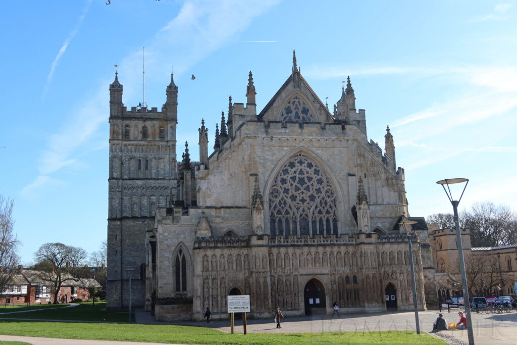
Exeter Cathedral
Description: Founded in 1050, Exeter cathedral was built in the Norman Style and because there is no central tower, the cathedral Nave has one of the longest uninterrupted vaulted ceilings in Europe. The ceiling artworks include grotesques and scenes of the murder of Thomas Becket and there is a 15th century Astronomical clock. The cathedral library is home to the famous Exeter Book, which holds the oldest collection of Old English Poems, and dates from 990 CE, but is not on public display.
2. Cathedral Close
Description: Opposite the cathedral lies Cathedral Close, an area of medieval buildings and cafes to relax in. In the Close stands a statue of Richard Hooker, an influential sixteenth century Theologian during the reign of Elizabeth I.
3. Exeter Guildhall
Description: Located in the High street, Exeter Guildhall is claimed to be the oldest municipal hall in England, as there has been a Guild recorded here since 1,000 CE. The current building was completed in 1470. The oak paneling in the main hall dates from 1594 and the carved oak door from 1593. After the Monmouth Rebellion in 1685, Judge Jeffries held the Bloody Assizes in this Guildhall. Although it is still a working building, it is open to the Public when not in use for Events.
4. Underground Passages Tour
Description: The underground tunnels which once brough clean water into the city can now be explored with guided tours. The guides tell stories that cover Exeter’s darker history of sieges, plagues and disease.
5. Gandy Street
Description: Gandy street is the location for shops, restaurants, cafes and clubs as well as the Phoenix Arts Centre. This cobbled alley is thought to have inspired J.K. Rowling’s Diagon Alley in the Harry Potter series.
6. Exeter Phoenix Arts Venue
Description: Located just off Gandy Street, the Phoenix Centre is a multi-arts venue which is home to art galleries, a solar-powered cinema, comedy, talks, and performances.
7. Royal Albert Memorial Museum (RAMM) and Art Gallery
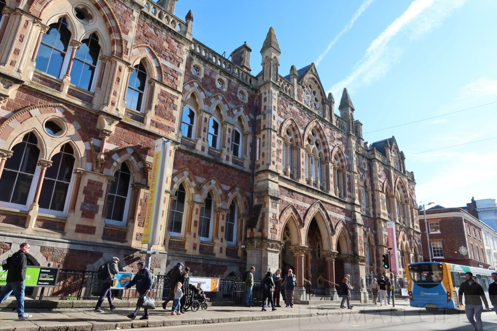
Royal Albert Memorial Museum, Exeter
Description: Located at Queen Street, it is open 10-5pm and closed Mondays. The Museum holds four main Collections consisting of Antiquities, Art, Natural History and World Cultures. The Roman Empire Collection displays artefacts which include Roman Amphorae, Brooches, Beads, Coins and Pottery. Of particular interest is the Seaton Hoard, a collection of 22,888 Roman coins called Nummi dated between 260-348 CE. From the Bronze Age are the Erme Ingots, a group of 44 Tin Ingots found in 1992 on the bed of the River Erme Estuary, 3 miles (5km) to the west of Burgh Island. The Ingots are round, oval and two are H-shaped, which matches the description by Diodorus Siculus (c.90-30 BCE) of the trade in Tin Ingots from southwest Britain in the 1st century BCE.
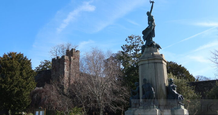
8. Northernhay Gardens
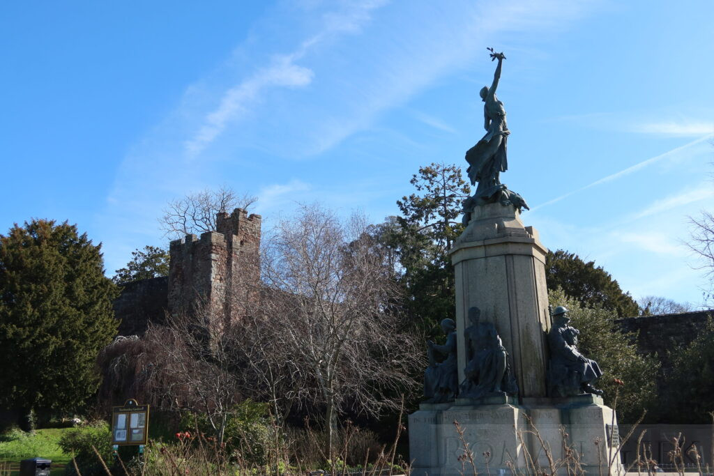
Northernhay Gardens, Exeter
Description: Located just outside the castle, Northernhay Gardens was created by the City Chamber in 1612 as a pleasure park for Exeter residents, making it the oldest public open space in England. The Gardens follow a long stretch of Roman wall and the only length of Saxon city wall in England.
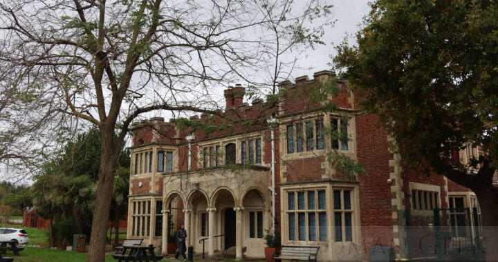
The city walls encompass Exeter castle, also known as Rougemont castle, where views of the exterior can be seen from Northernhay Gardens. It is now a private venue for events and weddings, but its courtyard can be accessed on weekdays for views of the front of the building.
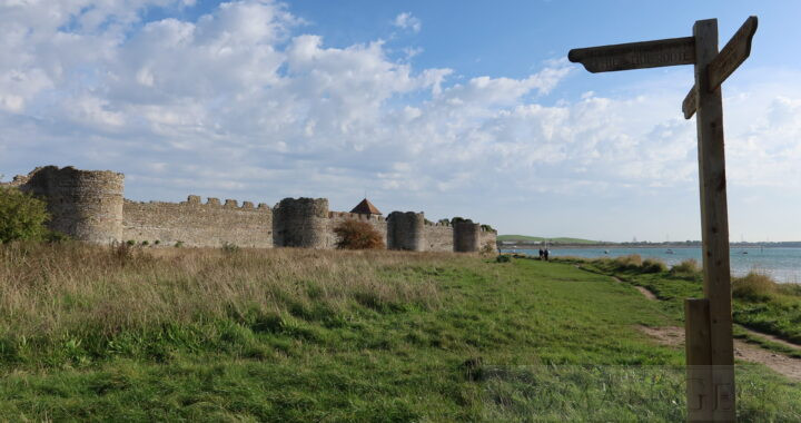
9. Exeter Medieval City Walls
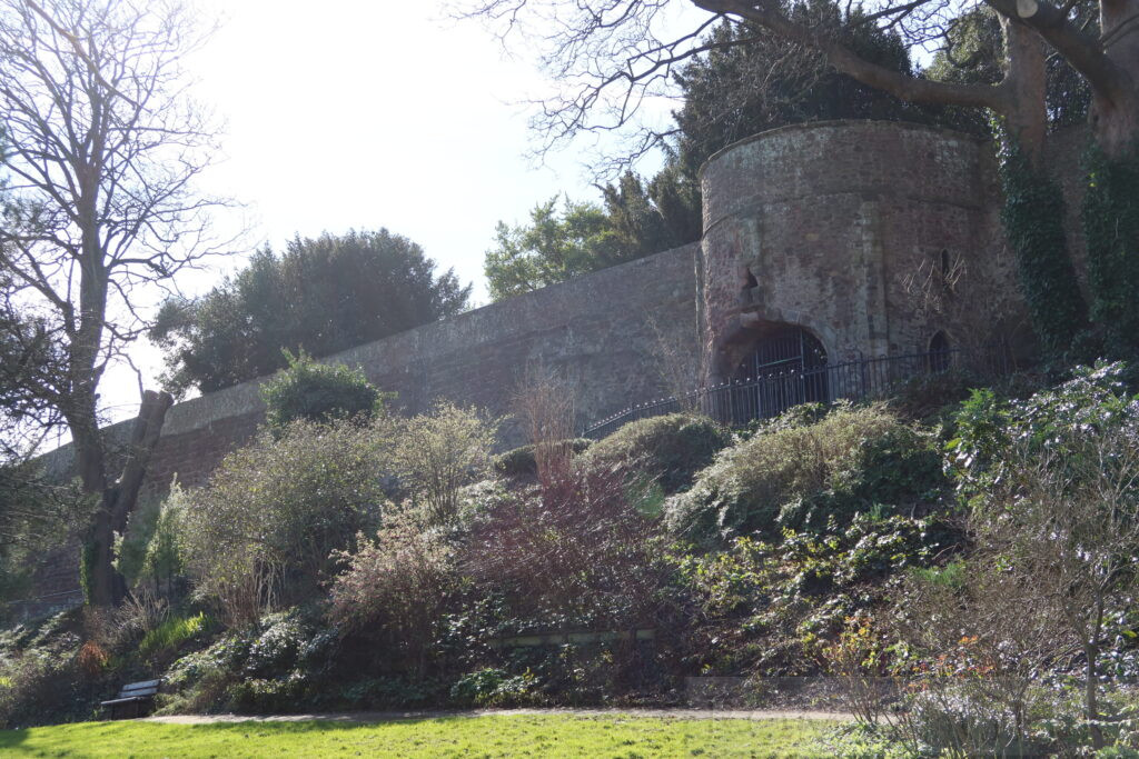
Exeter City Walls
Description: Located in Northernhay Gardens, the medieval city walls were built on top of the Roman Ramparts of the Fortress, with the Roman construction still visible in the lower part of the walls. The entire wall circuit can be walked around, with over 70% of the walls still intact.
10. Iron Bridge
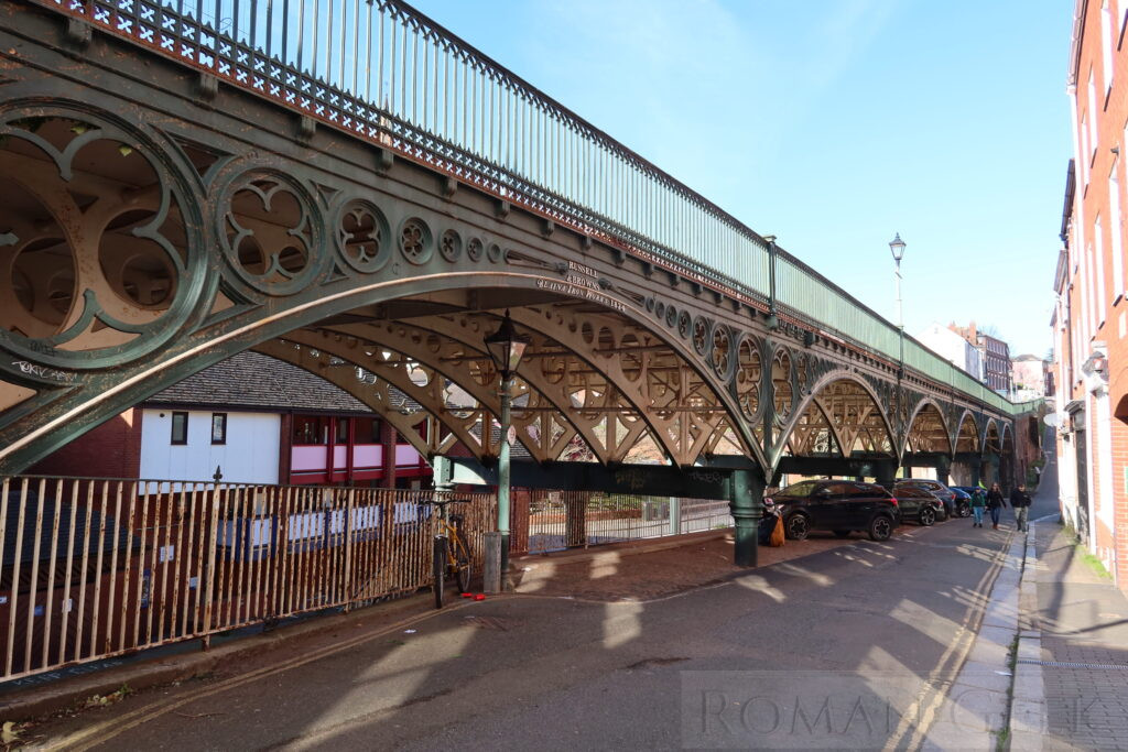
Iron Bridge, Exeter
Description: Opened in 1835, this cast iron bridge transformed the narrow hilly road into Exeter and enabled heavy horse drawn vehicles to travel easily across the valley on its level surface. It is still open for light road traffic as well as pedestrians.
11. The House That Moved
Description: Now located at 24 West Street, The House That Moved is a historic timber framed pre-Tudor building that dates from 1460. It was saved from demolition by moving it from one street to another. Edmund street and Frog street were about to be demolished to make way for the Exeter bypass. To save the building, a specialist contractor placed the entire house on steel girders supported by wheels. Edmund Street was then closed to traffic by the police, and the building was precariously moved at a snail’s pace, for 231 feet (70 metres) up the 1:10 gradient hill, from 16 Edmund Street to 24 West Street. The move took four and a half hours.
12. Old Exe Bridge
Description: Completed in 1214, this is the oldest surviving medieval bridge in Britain, and the oldest medieval bridge with a chapel. It almost certainly replaced a Roman wooden bridge that took the old Roman road to the west. It was replaced in 1778 and the arches across the river Exe demolished. It has been preserved in its own park just off Frog Street, near The House That Moved.
13. Exeter Quayside
Description: Located beside the river Exe, the Quayside is a relaxing area full of cafes and restaurants where performances and events are organised during weekends. The historic Custom House built in 1680 serves as a testament to Exeter’s thriving wool trade. Today, it serves as a visitor centre with exhibitions and interactive displays.
14. Exeter Ship Canal Basin
Description: Located along Haven road on the opposite bank to Exeter Quayside, it is reached by Butt’s Ferry, a pedestrian hand-pulled cable ferry crossing the river Exe. The historic Exeter Ship Canal was constructed in 1566, and runs for 5 miles (8km) to the Exe Estuary. The Canal Basin was constructed later in 1830. The canal’s main export was woolen cloth, mainly serge, while imports consisted of coal and timber.
Further Afield
15. Exeter Northcott Theatre
Description: Located on the Streatham campus of Exeter University, the Auditorium is built in a semicircle with a capacity for 464 spectators. Opened in 1967, it quickly developed a reputation for fostering new talent. Actors such as Celia Imrie, Robert Lindsay, Diana Rigg, Imelda Staunton and John Nettles all developed their careers here.
Travel Tips
- Best time to visit: Spring and autumn for mild weather and fewer tourists. There are multiple Festivals held in June and July and the Exeter Carnival is held in November.
- Photography hotspots: Exeter Cathedral, medieval City walls and castle, Iron Bridge, Old Exe Bridge
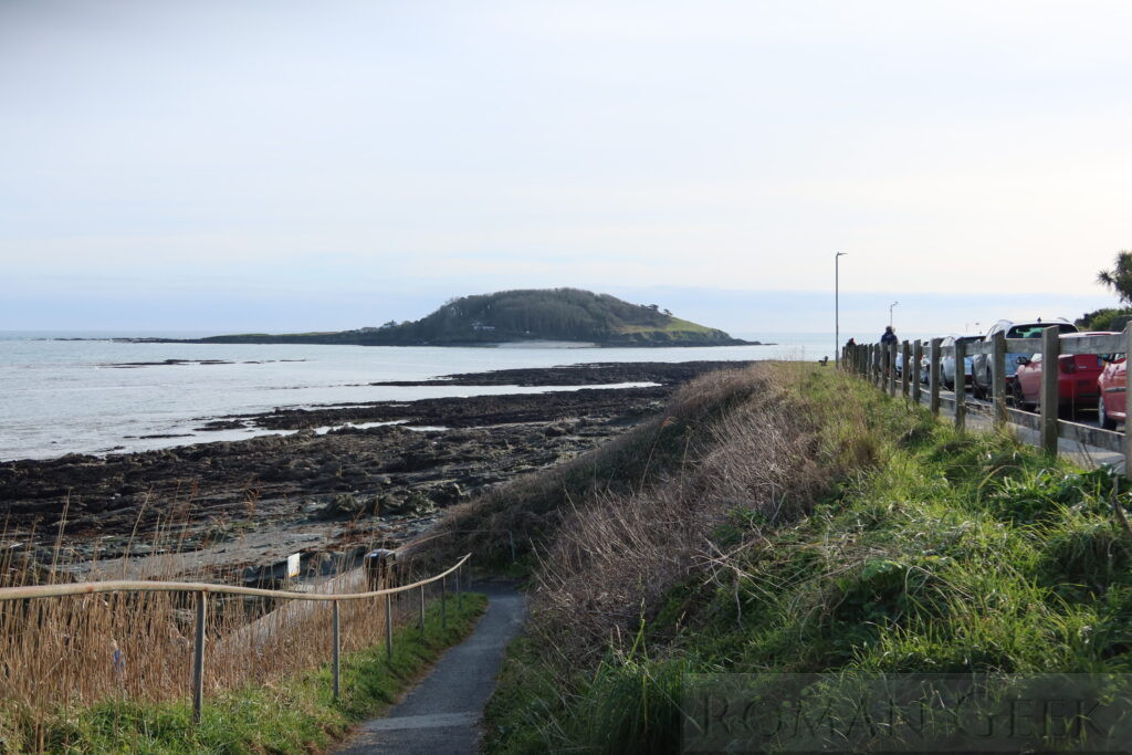
- Nearby Attractions: Burgh Island, Looe Island, Dorchester
Visitor FAQ
- What is Exeter famous for?
- Exeter is known for its 12th century medieval cathedral, Underground passages, Roman era city walls, a thriving Bookbinding industry for which it was awarded UNESCO city of literature in 2019, the Exeter Book – which contains the largest known collection of Old English Poetry dating from 990 CE, and Exeter University. Authors who mention Exeter include Charles Dickens, Agatha Christie and Daphne du Maurier, while J.K. Rowling attended University here.
- Can I see Roman Ruins in Exeter?
- Yes, the medieval city walls are built on top of the original Roman walls, which are visible. There are also many Roman artefacts in the Royal Albert Memorial Museum in Exeter.
- How far is Burgh Island from Exeter city centre?
- Are there Guided Tours of Exeter historical sites?
- Is Isca Dumnoniorum the same as Exeter?
- Yes, Exeter was built by the Romans as Isca Dumnoniorum in 55 CE, when they moved the Belgae tribe from their Oppidum nearby.
- Which Roman Province was Exeter located in?
- Which Roman Roads connected to Exeter?
- What was the role of Isca Dumnoniorum (Exeter) in the Roman Empire?
- Exeter served initially as a key military fortress for the defense of the southwest, with a strategic road leading northeast to another Legionary Fortress at Lincoln. The Exeter Fortress was occupied by the Legio II Augusta between 56-66 CE, after which it moved to Gloucester and then eventually on to Caerleon.
Quick Facts
- Modern Location: Exeter, England
- Category: Historic city centre, medieval cathedral, tourist destination
- Activities: Walking tours, Sightseeing, Photography
- Nearby Roman Site: Dorchester
- Nearest Roman road: Fosse Way
- Roman Province: Britannia
Nearby Attractions
Dorchester Roman Amphitheatre
Maiden Castle, Dorset
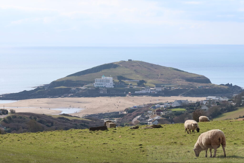
The tide is out at Burgh Island, Bigbury-on-Sea, Devon
Looe Island, Cornwall