The Ridgeway, Berkshire Downs

The Ridgeway

  • The Ridgeway is a 5,000 year old Bronze Age chalk road that connects Bronze Age hillforts positioned along the Berkshire Downs.
  • It is one of four pathways that combine to make the Greater Ridgeway that runs from Lyme Regis in Dorset to Hunstanton on the Wash in the North Sea.

The Route

The Icknield Way

  • This ancient east-west trackway possibly ran from Exeter to Hunstanton and consisted of:
    • The Wessex Ridgeway
    • The Ridgeway
    • Icknield Way Path
    • Peddars Way

The Four Highways of Medieval England


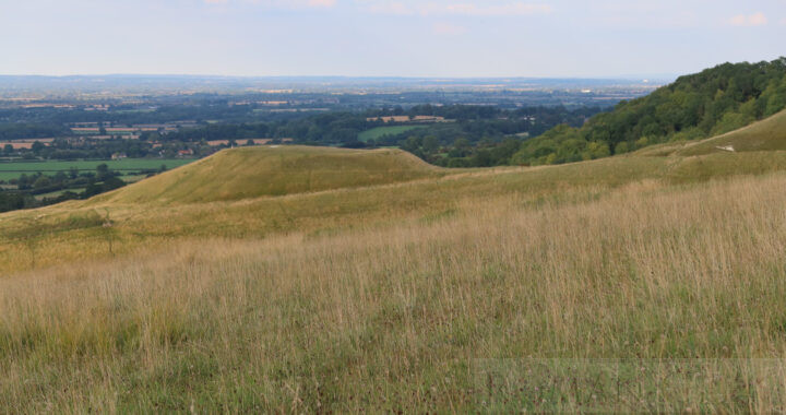
Uffington Castle, White Horse & Dragon Hill, Berkshire Downs

Famagusta

  • Famagusta is a deep water port founded in 274 BCE, after nearby Salamis was hit by an earthquake.
  • It is located 4 miles (6km) south from the ruins of Salamis, in the Turkish controlled area of Eastern Cyprus.

History of nearby Salamis and Cyprus

  • Finds from Salamis date to the 11th century BCE, when Copper was already being exported from Cyprus.
  • In 708 BCE, the Kings of Cyprus came under the control of Assyria and paid homage to the Assyrian King Sargon II.
  • Between 334/3 BCE, the Kings of Cyprus allied with Alexander the Great against Persia, and lent him their fleets. 120 ships belonginhg to the Kings of Cyprus besieged Tyre until it fell in 332 BCE. Cyprus then came under the control of Egypt.
  • In 58 BCE, Salamis became part of the Roman Province of Cyprus.
  • Salamis was rebuilt after an earthquake in the 4th century CE, by Constantius II (337-361 CE), who renamed it Constantia.
  • Cyprus was lost to the Arab Invasion of 654 CE, when the population abandoned Salamis and moved to Famagusta.

Roman Sites of Salamis

  • Theatre (restored), with 50 rows of seats for 15,000 spectators
  • Gymnasium (restored), with a colonnaded Palaestra.
  • Statue of Augustus
  • Baths
  • Public Latrines (with 44 seats)
  • Harbour Wall
  • Basilica
  • Water Cistern, near the Agora
  • The Roman Agora
  • Temple of Zeus
  • Necropolis

Museums

  • St. Barnabus Monastery and Icon Museum
    • near Salamis, Famagusta, N. Cyprus.


St. Barnabus Archaeological and Icon Museum


Constantinople

  • Constantinople was founded as the ‘New Rome’ in 330 CE by Constantine I on the existing city of Byzantium.
  • It became the Capital of the Eastern Roman Empire for the next 1,000 years. Since 1928 it has been renamed Istanbul.

History

Hellenistic Period (658-146 BCE)
  • In 658 BCE, the city was founded as Byzantium by the Greeks from Megara.
    • It was protected by a Wall with 27 Towers and 2 Gates on the landward side.
  • In 479 BCE, Pausanias, the Spartan General, conquered Byzantium then rebuilt the Wall.
  • In 340 BCE, the Wall was rebuilt to prepare for an attack by Philip II of Macedon.
Roman Period (146 BCE-395 CE)
  • In 146 BCE, Greece officially became a Roman Province and the city continued to be called Byzantium.
  • Byzantium became the capital of the Roman Province of Thracia.
  • In 193-96 CE the city was besieged by Septimius Severus who destroyed the Walls, then rebuilt them.
  • In 324-336 CE, Constantine I also besieged then rebuilt the city.
  • In 330 May 11 CE, the city was Inaugurated as ‘Roma Nova’ (New Rome), and already during his reign it was called Constantinople.
  • The Senate of Constantinople. Constantine I created a second Roman Senate of Eastern Roman Senators, and also Roman Senators who wished to move to Constantinople. They were encouraged by a free gift of land and grain.
  • In 330 CE, the city had a population of c. 30,000, by 400 CE around 300,000 and by 565 CE around 750,000.
  • In 324 CE, Constantine I built a new single Wall to the west of the Severan Wall.
  • In 368 CE, Valens completed the Aqueduct of Valens.
Byzantine Period (395-1453 CE)
  • In 395 CE, the Eastern Empire split permanently from the Western Empire, with Constantinople as its capital city. Historians refer to it as the Byzantine Empire
  • In 413 CE, Theodosius II constructed the first Walls of Constantinople.
  • In 437, 447 and 448 CE Earthquakes destroyed the Constantinian and Theodosian Walls.
  • In 448 CE Theodosius II ordered the damaged Walls to be rebuilt in 60 days to deter Attila the Hun, who avoided the city and went into Greece instead.
  • Imperial Library of Constantinople. Very little is known about this Library, except that it seems to have contained Works in both Greek and Latin. It may have contained many of the Books or copies of the Books from the Great Library of Alexandria.
Ottoman Period (1453-1922 CE)
  • Constantinople was the capital of the Ottoman Empire, which at its peak collected Tribute from 32 Provinces and a number of Vassal states, located in southeastern Europe, western Asia and northern Africa.
Republic of Turkey (1923-today)
  • Constantinople was renamed Istanbul in 1930.
  • Ankara became the capital of the new Republic of Turkey in 1923.

Museums

  • Istanbul Archaeology Museums
    • Archeological Museum: Osman Hamdi Bey Yokuşu Sokak Sok 34122, Gülhane, Istanbul
    • The museum holds over 1,000,000 items from the Anatolian, Hellenistic, Roman, Byzantine and Ottoman Empire Periods.
    • The museum holds seven of the Porphyry Sarcophagi in which the Byzantine Emperors were buried.
  • Great Palace Mosaic Museum
    • The museum holds a series of excavated floor mosaics that decorated a peristyle court of the Palace, possibly dating to Justinian I (527-565 CE).

Roman and Byzantine Sites

  • Hagia Sophia (537 CE)
    • It was built as a Cathedral in 537 CE by Justinian I and was in use until 1453 CE. It was then used as a Mosque from 1453 until 1931 CE. Today it is a Museum and a Mosque.
  • Aqueduct of Valens (368 CE)
    • Valens (364-378 CE) completed the aqueduct in 368 CE. It has a dramatic viaduct between two hills in Istanbul which is still standing today.
    • The water system consisted of 160 miles (250km) of supply lines, three open reservoirs and one hundred underground cisterns.
  • Basilica Cistern
    • The Cistern is located under the Stoa Basilica, from which it derives it’s name, on the First Hill of Constantinople. The cistern featured in the James Bond film ‘From Russia with Love’.
    • It was completed before the Aqueduct of Valens was finished in 378 CE.
    • The Cistern is largest underground cistern in Constantinople, being approximately 450 x 210 feet (138 x 65m), with a capacity for 100,000 tons of water.
    • It has 336 marble columns are each 30 ft (9m) high and are arranged in 12 rows which support the ceiling. The cistern is lined by a brick wall sealed with waterproof mortar.
  • Obelisk of Theodosius
    • The Hippodrome is now Sultan Ahmet Square.
    • It was moved in 390 CE from Alexandria in Egypt to Constantinople by Theodosius I (379-395 CE), and positioned on the Spina of the Hippodrome, where it still stands today.
  • Harbour of Eleutherios (c.395 CE)
    • This is an excavation site which is not open to visitors. It is located under the Yenikapi district of Istanbul.
    • In 2005 whilst digging the East West Bosphorus Rail Tunnel, excavators uncovered the old Harbour of Eleutherios, built by Theodosius I (379-395 CE). It was also known as the Harbour of Theodosius (Portus Theodosiacus).
    • Excavators unearthed sections of the Wall of Constantine I and 35 Byzantine Ship remains from the seventh to tenth centuries CE including Galleys.
  • Hippodrome of Constantinople (203 CE)
    • A U-shaped racetrack built by Septimius Severus and rebuilt by Constantine I in 324 CE, to accommodate 100,000 spectators.
    • Today, it is named Sultan Ahmet Square and contains several Monuments:
      • The Serpent Column made in 478 BCE, it is a bronze memorial to the Greek victory at the Battle of Plataea (479 BCE).
      • Obelisk of Theodosius
      • The Walled Obelisk
      • The statue of Porphyrius
  • Great Palace of Constantinople (no longer extant)
    • Located in Old Istanbul, only a few vestiges remain today, but some of the mosaics have been excavated and are now in the Great Palace Mosaic Museum.
    • In 330 CE, the Great Palace of Constantinople was built by Constantine I.
    • ‘The Porphyra’ was the official delivery room for pregnant Empresses, and was lined with red Porphyry marble from the Porphyry Mountain in Egypt (no longer extant).
  • Great Palace Mosaic Museum
    • The museum holds a series of excavated floor mosaics that decorated a peristyle court of the Palace, possibly dating to Justinian I (527-565 CE).
  • Church of the Holy Apostles (no longer extant)
    • The Church was built by Constantine I between 330-337 CE, and was the second most important church after the Hagia Sophia. The Church was destroyed in 1462 CE and no vestiges remain.
    • It was the Mausoleum for the Eastern Roman Emperors of the Byzantine Empire starting with Constantine I, in 337 CE until 1056 CE with Theodora, after which there was no more space. The Emperors were placed in Porphyry Sarcophagi.
    • Seven of the Porphyry Sarcophagi are located in the Istanbul Archaeology Museums.
  • Walls of Constantinople (324-c.340 CE)
    • A single Wall with towers was built by Constantine I to protect the new city of Constantinople.
    • The Theodosian Walls were then built 1.5 miles (2km) to the west of the Constantinian Wall, by the Emperor Theodosius I (402-450 CE).
    • The Wall consists of a large inner Wall with 96 Towers, below it a smaller outer Wall, and in front of that, a moat.
    • Despite attacks, earthquakes and floods, the Walls stood firm until 1453 CE and fell with the arrival of cannon.
    • The Walls have been restored and can be visited today.

Roman Roads


Constantinople-Istanbul

Aptera

  • Aptera is an Archeological Site located 9 miles (15km) from Chania in the Chania Region of Crete.
  • When the Romans invaded in 69 BCE, it was included in the Province of Crete.

History

  • Aptera was a city during the Minoan Civilisation.
  • The ancient city flourished during the period of Classical Greece.
  • After the Roman invasion of 69 BCE, it continued as a successful city until it was destroyed by an earthquake during the 7th century CE.

Greek and Roman Sites

  • Archeological Site of Aptera
    • City Walls (2.5 miles or 4km long) built in 3rd century BCE.
    • Roman Theatre
    • Roman Cistern with three vaults which held water for the Roman Baths.
    • Roman Baths complex
    • Roman Town Villa
    • Remains of Ancient Greek Doric Temples


Archeological site of Aptera

Kissamos

  • Kissamos is a town on the island of Crete located at its most western point, 23 miles (37km) west of Chania.
  • A ferry links the harbour to the islands of Antikythera and Kythira and Gytheio on the mainland of the Peloponnese.

Description

  • It was marked as one of two towns called Cisamos on the Peutinger Table and Strabo named it as the port for nearby Aptera.
  • Cisamos was destroyed by the Crete Tsunami of 365 CE.

The Roman Sites

  • Greco-Roman Baths

Museums

  • Kissamos Archeological Museum


Petra

History

  • Location:
    • Petra is surrounded by high rocky mountains, cliffs and gorges.
    • From the east Petra is only accessible through a narrow pass called the ‘Siq’ (the shaft) which is only 10-13 feet (3-4 m) wide in parts, allowing only two camels to pass each other. This is the route most tourists take to enter Petra.
    • To obtain water, apart from a mountain stream, the Nabateans built dams and conduits to control flash floods and store the water.
  • Nabataean Kingdom:
    • Petra was founded c.312 BCE, although it had been a Sanctuary for centuries. In its heyday, Petra had a population of 30,000.
    • Unusually, the buildings in Petra were cut from the rock.
    • Petra is also known as the ‘Rose city’ because of the pink colour of the Rock it is carved from.
    • Petra was a Lost city to the West until its rediscovery in 1812 by the Swiss explorer Johann Ludwig Burckhardt.
  • Acquisition by the Roman Empire:
    • Petra was annexed by the Roman Empire under Trajan in 106 CE. It was then included in the Province of Arabia Petraea giving the Romans control of the Incense Road.
    • In 363 CE Petra experienced an earthquake that started its decline.
    • In 663 CE the Arab Empire conquered Petra, and it was left uninhabited.
    • During the First Crusade up until 1189 CE it was part of the Kingdom of Jerusalem. Two Crusader castles were built close to Petra to defend it.
  • Rediscovery in 1812 CE:
    • Petra was rediscovered by the Swiss Explorer John Lewis Burckhardt on 22nd August 1812 CE.
  • The Incense Road
  • Wadi Faynan
    • Located in southern Jordan, this contains a huge copper mining site. It is thought to have been the location of King Solomon's Mines.
    • It was extensively mined throughout history, but particularly during the Roman Empire.
    • Petra was 30 miles (48km) to the south of these Mines and controlled the Copper trade.

Pre-Roman Monuments

  • Hydraulic Buildings:
    • Diversion Dam
    • Mithlim tunnel
    • Water Channels
    • Aqueducts
    • Reservoirs
  • The Rock cut Temple-Tombs: these are ‘The Royal Tombs’, a mix of Greek and Eastern Styles.
    • Khasneh or Treasury is in the Greek Style. (the most striking pf Petra’s monuments)
    • Urn Tomb
    • Palace Tomb
    • Corinthian Tomb
    • The ‘Deir’ or Monastery.
  • The Copper Mines
  • Bab Al Siq Gateway
  • Triclinium Banqueting Hall with the Obelisk Tomb on top.
  • Qasr el Bint Temple (Palace of the Pharoah’s Daughter)

Roman Monuments

  • Nymphaeum (public Fountain)
  • Temple of the Winged Lions
  • Colonnaded Street
  • Triple Arched Gate

Museums

  • New Museum of Petra
    • Located beside the Visitor Centre in Petra.
    • It holds all the Artefacts from the Old Petra Museum and the Collection covers the Nabataean, Roman and Byzantine Periods.

Roman Roads

Films featuring Petra


Petra, Jordan

Piercebridge Roman Site

Piercebridge

  • Piercebridge is a village on the River Tees in County Durham.
  • It is the location of a Roman Fort and a Roman bridge which carried Dere Street over the river Tees.

History

  • The history of Piercebridge is documented in two books by the late local Historian, Raymond Selkirk: ‘The Piercebridge Formula’ (1983) and ‘On the Trail of the Legions’ (1995).

Roman Sites

  • Piercebridge Roman Fort
  • Roman Bridge carrying Dere Street

Roman Roads


Photo and map: Piercebridge Roman Bridge

Timna

  • The Timna valley is located 19 miles (30km) north of Eilat in Israel.
  • It has 2,000 tons of slag from ancient Copper Mines that have been worked for over 6,500 years.

Description

  • The so-called ‘King Solomon’s Pillars’ are rock formations which stand at the end of the Timna valley, which were named by the American Archeologist Nelson Glueck in 1930.
  • Just below the base of the Pillars was found a temple to Hathor, the Egyptian Goddess of Mining, built in the 14th century BCE.


Timna Valley

Sremska Mitrovica

  • Sremska Mitrovica is a city located on the river Sava in Serbia and holds the Ruins of the Roman city of Sirmium.
  • Sirmium was the capital of Pannonia Inferior and was the birthplace of ten Roman Emperors known as the Illyrian Emperors.

Roman Sites

  • Sirmium Imperial Palace
    • Located at Pivarska 2, Sremska Mitrovica, 320510, Serbia.
    • The excavated section of the ruins is housed in this dedicated building and can be visited.

Museums

  • Museum of Srem
    • Located at 15 St. Stefan Square, Sremska Mitrovica.
    • The Lapidarium of the museum holds a collection of Roman stone monuments, along with mosaics and other artefacts excavated from Sirmium.

History

  • In 293 CE, with the formation of the Tetrarchy under Diocletian, Sirmium became one of the four Capitals of the Roman Empire along with Augusta Treverorum Trier, Mediolanum Milan and Nicomedia (Izmit).
  • In 318 CE, Sirmium became the Capital of the Praetorian Prefecture of Illyricum.
  • In 379 CE, Sirmium and western Illyricum was attached to the Praetorian Prefecture of Italia and eastern Illyricum continued as a separate Prefecture whose capital was at Thessalonica.
  • In 441 CE Sirmium was lost to the Hunnic Empire.
  • Between 567-582 CE, Sirmium briefly returned to the Eastern Roman Empire, but then was lost permanently.

The Illyrian Emperors

Meditations

  • ‘Meditations’ by the Roman Emperor Marcus Aurelius, is thought to have been partly written whilst he was in Sirmium and also whilst he was based in Aquincum, Pannonia.
  • It was written in 167 CE, in 12 books, consisting of guides to self awareness and self improvement. Marcus Aurelius wrote whilst he was staying at the Emperor’s Palace in Sirmium.

Sites Nearby

  • Petrovaradin Fortress, Novi Sad
    • Labelled the ‘Gibraltar of the Danube’, Petrovaradin Fortress overlooks the Danube and the city of Novi Sad on the opposite bank.
    • It is built over the Roman Fortress of Cusum.
  • Fruska Gora National Park
    • Fruska Gora is a mountain shared with Croatia, in a region called Smyrna.
    • The Serbian part reaches 50 miles (80km) east to west and 9 miles (15km) from north to south.
    • The Romans called Fruska Gora ‘Alma Mons’ meaning ‘fertile mountain’. The first vines were planted during the reign of the Roman Emperor Marcus Valerius Probus (276-282 CE), one of the Illyrian Emperors.
    • It is a large wine producing area, producing some prestigious wines such as ‘Bermet’.
    • There are 16 Serbian Orthodox monasteries on the mountain, leading the Holy Synod of the Serbian Orthodox Church to declare Fruska Gora a Holy Mountain.


Sremska Mitrovica (Sirmium)

Amman

  • Amman is the capital city of Jordan on the river Zarqa, a tributary of the river Jordan.
  • It was known as Philadelphia by the Greeks and Romans and was located in the Province of Arabia Petraea.

History

  • Amman was originally known as Rabbath Ammon, capital of the Biblical Ammonite Kingdom between c. 650-330 BCE.
  • After the conquest of the Levant by Alexander the Great, it became known as Philadelphia.
  • Philadelphia was one of the ten cities of the Decapolis until it was absorbed into the Province of Arabia Petraea.

Roman Sites

  • Roman Theatre (intact, with seating for 6,000 spectators)
  • Roman Temple of Hercules (Pillars only, located in the Amman Citadel)

Other Sites

  • Amman Citadel
    • This is one of the seven hills of Amman, dating from 1,800 BCE.
    • The Umayyad Palace (8th century CE)
    • Fortification Walls and Gate of Ammon (renovated)
    • Amman citadel Mosque

Museums

  • Amman Archeological Museum
    • Located in the Amman Citadel, at XW3M+MP9, Amman.
    • The Museum holds the Copper Scroll, one of the Dead Sea Scrolls from Qumran, the rest are in the Israel Museum in Jerusalem.

Roman Roads

  • Via Traiana Nova
    • Amman was connected to this north-south Highway between Egypt and Mesopotamia.


Amman